
With more public road miles than any other state, California’s greatest travel experiences are often found on the routes designed for slowing down, not speeding through.
California rewards drivers who leave the interstates behind and follow the quieter lines on the map. According to the Federal Highway Administration, the state contains more than 396,000 miles of public roads, more than any other state in the country. Many of its most memorable drives run through redwood forests, coastal cliffs, high deserts, and mountain valleys that rarely appear on standard travel itineraries.
These back roads reveal a different side of California, shaped by patience and discovery rather than speed. Curves replace straightaways, and small towns replace rest stops. Each mile slows you down and turns the drive itself into the main attraction.
Tioga Road and Tioga Pass, Highway 120
Tioga Road cuts through Yosemite’s high country, rising to Tioga Pass at roughly 9,945 feet, according to National Park Service elevation data. The Federal Highway Administration recognizes the Tioga Road–Big Oak Flat Road corridor as a National Scenic Byway. The designation is tied to its granite domes, alpine lakes, and subalpine meadows rather than traffic volume.
Because winter snow closes the pass for months, typically reopening only in summer and early fall per Yosemite National Park operations reports, the drive carries a sense of urgency. Many Yosemite visitors never see this side of the park, clustering instead in the valley below, which leaves the high country feeling like a secret despite its fame.
In a single day, drivers can pass from the sagebrush flats of U.S. 395 into near alpine terrain and back down again, a vertical sweep that feels uniquely Californian.
Jacinto Reyes National Scenic Byway, Highway 33
Highway 33 north of Ojai follows a route once called Maricopa Road, completed in 1931 to connect isolated ranches with Ventura County’s seat. This history is documented in the California Department of Transportation archives. Today, this stretch is formally designated the Jacinto Reyes National Scenic Byway, threading into Los Padres National Forest and the open reaches of the Cuyama Valley.
The road remains narrow and lightly serviced, a deliberate contrast to Southern California’s engineered sprawl. Cell service fades, chaparral takes over, and the landscape recalls a ranching past that still shapes the region. It is one of the rare places where Los Angeles feels far away, not because of distance but because of terrain.
Ebbetts Pass National Scenic Byway, Highway 4
Ebbetts Pass on Highway 4 offers a different Sierra crossing, one that the Federal Highway Administration also lists as a National Scenic Byway. Unlike Interstate 80 or U.S. 50, this route narrows dramatically, in places lacking a centerline and excluding large trucks entirely, as noted in Caltrans road specifications.
The payoff is a quieter Alpine, California. Meadows, volcanic ridges, and high lakes unfold without the infrastructure that signals mass tourism. Traffic counts published by the California Transportation Commission consistently rank Ebbetts Pass among the least traveled trans Sierra routes, a statistic that explains its appeal to drivers seeking space rather than speed.
Volcanic Legacy Scenic Byway, Northern California
The Volcanic Legacy Scenic Byway spans multiple states. Its California segment winds through Lassen Volcanic National Park and the landscapes surrounding Mount Shasta. The route is defined by geology rather than culture, steaming fumaroles, cinder cones, lava beds, and high country lakes cataloged by the National Park Service.
This is California stripped of its coastal shorthand. The scenery feels closer to Iceland or the Pacific Northwest, a reminder that the state’s identity includes fire and uplift as much as sun and surf. As a back road, it offers distance from stereotypes as much as from crowds.
Arroyo Seco Historic Parkway, Route 110
The Arroyo Seco Parkway, now part of Route 110, opened in 1940 as the nation’s first freeway, according to the National Trust for Historic Preservation. It is also designated a National Scenic Byway, a rare title for an urban corridor.
Its narrow lanes, tight curves, and short ramps preserve a 1930s design logic that feels almost intimate by modern standards. Running between downtown Los Angeles and Pasadena, it functions as an urban back road, a reminder that even megacities once planned for slower movement and landscaped edges.
Angeles Crest Highway, Highway 2
The Angeles Crest Highway climbs from La Cañada Flintridge into the San Gabriel Mountains. It traverses roughly 66 miles of forest and ridgeline, as documented by Angeles National Forest route maps. Despite its proximity to metropolitan Los Angeles, it quickly sheds suburbia for pine forest, cliffs, and overlooks.
Truck traffic is limited, and seasonal closures from snow, fire, or rockfall are part of its character rather than an inconvenience. For Angelenos, it has long served as an escape hatch, a road that replaces brake lights with stars in under an hour.
Save this article
Big Sur Coast Highway, Highway 1
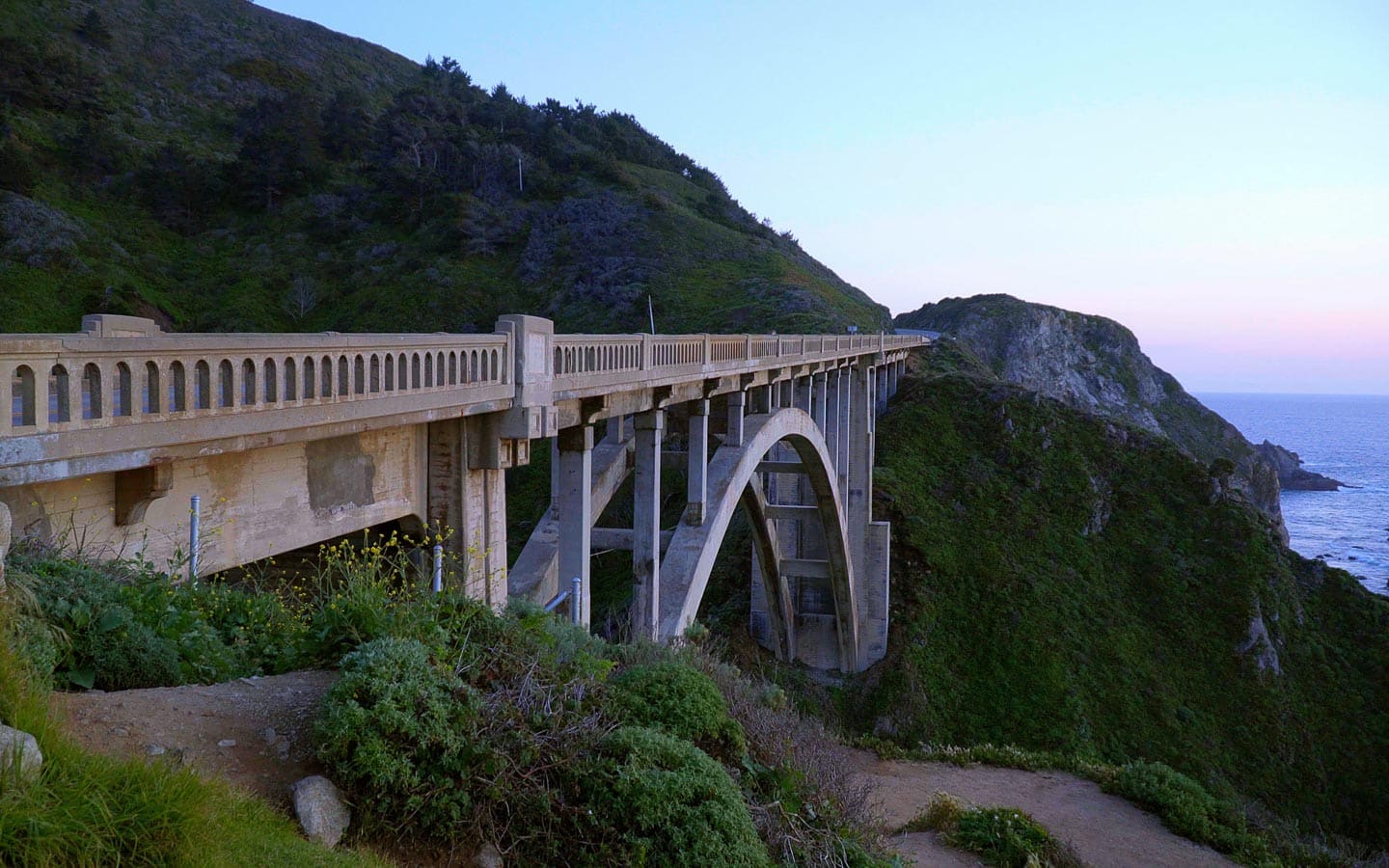
The Big Sur section of Highway 1, roughly between San Simeon and Carmel, carries its own federal recognition as the Big Sur Coast Highway National Scenic Byway. The designation highlights not convenience but exposure, cliffs plunging into the Pacific, bridges arcing over canyons, and a road that clings to geology more than it conquers it.
Landslides, fog, and periodic closures documented by Caltrans keep speeds low and attention high. Pullouts replace towns, and state park trailheads stand in for services. Treated as a back road rather than a bucket list blur, this stretch becomes less about checking landmarks and more about accepting the terms the coast sets.
Mojave Desert back roads, Route 66, and Kelbaker Road
The California Historic Route 66 Needles to Barstow National Scenic Byway traces a quieter stretch of the Mother Road. It is recognized by the National Scenic Byway Foundation for its preserved motels, ghost towns, and long desert horizons.
Traffic here is light, nostalgia intact.
Kelbaker Road cuts deeper, slicing through Mojave National Preserve past the Kelso Dunes and the Granite Mountains. These landscapes are managed by the National Park Service for their ecological and visual isolation. Together, these roads form a desert passage defined by silence and scale, the cinematic California of empty asphalt and endless sky.
Key Takeaway
As California reinvests in drive-based travel, the effort is backed by Visit California’s spending forecasts and the strategic promotion of scenic byways. The state is quietly reminding travelers that its greatest luxury is space.
These back roads offer not just views but perspective. They prove that California’s future as a road trip destination depends less on speed and more on the willingness to slow down.
More articles:
- 12 cruise dress code rules that spark debate every time
- 16 things you should never leave in your cruise cabin on port days
- 13 Hidden Cruise Risks Most Travelers Don’t Realize Until It’s Too Late
10 Insanely Fast Trains That Make Air Travel Look Slow

Rail travel has come a long way from the slow chugging of steam engines. Today, the race for the fastest train has become a high-speed pursuit of groundbreaking technology, pushing the boundaries of what’s possible on rails. From maglev marvels to sleek bullet trains, these trains don’t just break records; they redefine them. Here’s a look at the 10 fastest trains on Earth, each moving faster than most airplanes. Learn more.
8 financial mistakes travelers should avoid in Mexico

Traveling through Mexico can feel effortless, from booking boutique hotels to paying for street tacos on the go. Yet money mistakes can quietly turn a dream trip into an expensive lesson. Many travelers focus on flights and itineraries but overlook everyday financial decisions that shape their budget once they arrive. Exchange rates, payment methods, and local banking norms differ from those at home, and misunderstandings can drain funds faster than expected.
The stakes are higher than most people realize. According to data from the Consumer Financial Protection Bureau, international travelers can lose money on each transaction. Losses typically range from 3 to 10 percent when foreign transaction fees, poor exchange rates, and ATM charges are combined. Learn more.
10 travel scams targeting tourists

Vacations are supposed to be carefree, but a single clever scam can empty your wallet faster than any overpriced souvenir.
Planning a vacation is usually the highlight of the year, but falling for a scheme can ruin the fun before it even starts. Scammers are getting smarter and using advanced technology to trick even the most experienced globetrotters into handing over their hard-earned cash. You need to stay alert because these criminals often target distracted visitors who are just trying to relax. Learn more.